Tropical Depression May Enter Philippine Area of Responsibility Amid Easterlies, Northeast Monsoon — PAGASA
Key Takeaways
- •PAGASA reported on Friday, November 6, 2026, that a tropical depression could enter the Philippine Area of Responsibility.
- •Easterlies and the northeast monsoon, locally called the amihan, are currently influencing weather conditions across the Philippines.
- •On average, about 20 tropical cyclones enter or develop within the PAR each year, and systems entering the zone are given local names.
- •A tropical depression is PAGASA's lowest cyclone classification and may strengthen into a tropical storm or typhoon while over open water.
- •The published report omitted the system's location, strength, and expected movement, making PAGASA's succeeding bulletins the primary official source for updates.
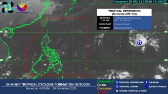
A tropical depression may enter the Philippine Area of Responsibility (PAR), the state weather bureau PAGASA reported on Friday, November 6, 2026, as easterlies and the northeast monsoon continue to influence weather conditions across the Philippines.
The Philippine Atmospheric, Geophysical and Astronomical Services Administration (PAGASA), an agency under the Department of Science and Technology (DOST), monitors tropical cyclones within the PAR, the country's designated meteorological monitoring zone in the western Pacific. The Philippines lies along the western Pacific's tropical cyclone corridor, and PAGASA's climatological averages indicate that around 20 tropical cyclones enter or develop within the PAR in a typical year — a regularity that makes cyclone monitoring a standing function of the bureau. Weather systems that enter the PAR are assigned local names, and the bureau issues regular bulletins and advisories for areas in their path.
A tropical depression is the lowest classification in PAGASA's tropical cyclone category system, denoting maximum sustained winds below tropical-storm strength. In general, tropical depressions can strengthen into tropical storms or typhoons while moving over open water, depending on conditions at sea, which is why changes in a system's structure and intensity are tracked through each succeeding bulletin.
The easterlies are warm, humid winds from the east, typically originating over the Pacific Ocean; they commonly bring cloudy skies, isolated rain showers, and thunderstorms to parts of the archipelago. The northeast monsoon, locally known as the "amihan," is a seasonal weather pattern in which cool, dry air from mainland Asia moves over the country, usually from late in the year through the early months of the following year, bringing cooler temperatures and occasional light rain.
Specific details on the tropical depression's location, strength, and expected movement were not included in the report as published by BusinessWorld Online. As the situation develops, PAGASA's succeeding bulletins would carry updated position, intensity, and any rainfall or wind advisories for areas in the system's path, making these the primary official reference to watch if the depression crosses into the PAR.