Hurricane Lowell Pulls Away From Hawaii as Rain Focuses on Midwest Cold Front
Key Takeaways
- •Hurricane Lowell is weakening and moving away from Hawaii after bringing flash flooding and hurricane-force gusts of 74 mph or greater to Kauai and Niihau.
- •Potential Hawaii agricultural losses include bananas, papayas, guavas, passion fruit, vegetables, nursery products, nuts, and damage to livestock pens and poultry houses, affecting mainly local and specialty markets rather than national commodity balances.
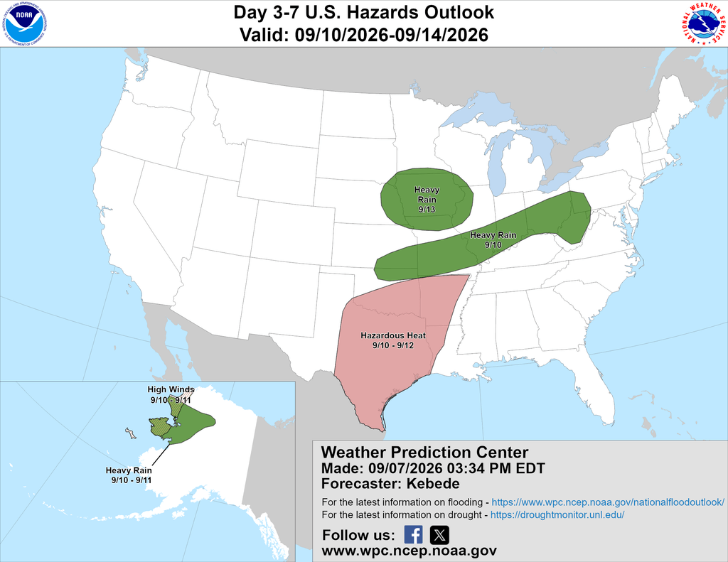
- •Five-day rainfall of 1 to 3 inches or more is forecast from the central Plains to the central Appalachians, with separate heavy showers expected along the Gulf Coast excluding southern Texas.
- •A shift to cooler, wetter conditions in the Midwest could slow crop drydown and delay field access during early-season harvest activity.
- •Gulf Coast growers are monitoring potential disruption to cotton, rice, and sugarcane fieldwork typical of the region in late summer.
By Greg Soulje — Brownfield Ag Weather, September 8, 2026
Hurricane Lowell, which grazed Kauai County overnight, will continue to weaken and move away from Hawaii. On Kauai and Niihau, agricultural impacts tied to flash flooding and hurricane-force wind gusts of 74 mph or greater could include damage to bananas, papayas, guavas, passion fruit, vegetables, nursery products, and a variety of nuts. Infrastructure such as livestock pens and poultry houses could also sustain damage. Hawaii's tropical fruit and nursery production, while small relative to mainland row-crop agriculture, supplies local and specialty markets, so storm losses there tend to affect growers and regional supply chains rather than national commodity balances.
On the mainland, heat will retreat from the central Plains and southern Corn Belt but persist through the remainder of the week across the south-central U.S. The western U.S. is in line for a brief warming trend, though cool conditions will return late in the week across the northwestern half of the region. The timing matters for Midwest fieldwork: early September is when late-season crop development and initial harvest activity for some crops are underway, so a shift to cooler, wetter conditions can slow drydown and delay field access.
For much of the week, precipitation will concentrate along a slow-moving cold front currently draped across the upper Midwest. That front should cross the Ohio River and middle Mississippi Valley around the middle of the week, after which rain showers will refocus farther north as a new cold front arrives.
Five-day rainfall totals are expected to reach 1 to 3 inches or more from the central Plains to the central Appalachians. A separate area of locally heavy showers is anticipated along and near the Gulf Coast, excluding southern Texas. Rainfall of that magnitude, falling on cropland across the Corn Belt, can ease late-season dryness where it exists but also raises the risk of localized ponding and flooding in low-lying fields; Gulf Coast growers, meanwhile, will be watching for any disruption to cotton, rice, and sugarcane fieldwork typical of the region in late summer.
Source: Brownfield Ag News
